Australia investigates possible debris from MH370 in Indian Ocean
Updated: 2014-03-20 15:34
(Agencies)
|
|||||||||||
|
 |
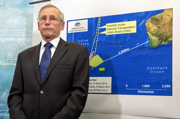
| John Young, general manager of the emergency response division of the Australian Maritime Safety Authority (AMSA), answers a question as he stands in front of a diagram showing the search area for Malaysia Airlines Flight MH370 in the southern Indian Ocean. [Photo/Agencies] |
Investigators piecing together patchy data from military radar and satellites believe that, minutes after its identifying transponder was switched off as it crossed the Gulf of Thailand, the plane turned sharply west, re-crossing the Malay Peninsula and following an established commercial route towards India.
What happened next is unclear, but ephemeral pings picked up by one commercial satellite suggest the aircraft flew on for at least six hours. That would be consistent with the plane ending up in the southern Indian Ocean.
The methodical shutdown of the communications systems, together with the fact that the plane appeared to be following a planned course after turning back, has focused particular attention on the pilot and co-pilot.
The FBI is helping Malaysian authorities analyse data from a flight simulator belonging to the captain of the missing plane, after initial examination showed some data logs had been deleted early last month.
A Malaysian official with knowledge of the investigations into the pilots said three simulator games that 53-year-old pilot, Zaharie Ahmad Shah, had played were being looked at.
"We are following up on the data logs being erased," the source said. "These could be logs of the games that were erased to free up memory, so it may not lead us to anything. He played a lot of games, going into hundreds and thousands of hours."
An unprecedented multinational search for the plane has focused on two vast search corridors: one arcing north overland from Laos towards the Caspian Sea, the other curving south across the Indian Ocean from west of Indonesia's Sumatra island to west of Australia.
Australia is leading the search in the southern part of the southern corridor, with assistance from the U.S. Navy.
The depth of the water where the possible debris has been sighted would likely make recovering the "black box" voice and data recorders that may finally unlock the mystery of what happened aboard Flight MH370 extremely challenging.
University of Western Australia Professor of Oceanography Charitha Pattiaratchi said that, based on currents in the area, if the debris is from the plane it probably would have gone into the water around 300-400 km (180-250 miles) to the west.
The search area covered an ocean ridge known as Naturalist Plateau, a large sea shelf about 3,500 metres (9,800 feet) deep, Pattiaratchi said. The plateau is about 250 km (150 miles) wide by 400 km (250 miles) long, and the area around it is close to 5,000 metres (16,400 feet) deep.
"Whichever way you go, it's deep," he said.
Related Stories
Missing jet will strengthen China and Malaysia ties, expert 2014-03-19 22:54
Malaysia rejects criticism of lack of co-op in plane search 2014-03-18 18:59
Prayer assembly for missing Malaysia Airlines jetliner 2014-03-18 17:44
Malaysia police probe flight engineer on missing plane 2014-03-17 13:47
Chinese joint working group urges Malaysia to intensify, expand search 2014-03-17 03:25
Today's Top News
China opens more maritime space for development
Experts warn as yuan dips further
Hotline helps smokers 'start quitting'
Australia finds possible debris from MH370
Pro-Russians storm naval HQ
Tour adds 'new dimension' to ties
Ukraine gives up CIS chairmanship
Beijing tightens expense reporting
Hot Topics
Lunar probe , China growth forecasts, Emission rules get tougher, China seen through 'colored lens', International board,
Editor's Picks

|

|

|

|

|

|


