Ancient Silk Road map comes home
 |
|
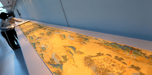
A map of the ancient Silk Road that dates from the Ming Dynasty (1368-1644) is unrolled by antiquities preservation personnel. The historic, 30-meter-long map, painted on silk, was donated on Thursday to the Palace Museum in Beijing. [Jiang Dong/China Daily] |
A huge colored map of the Silk Road from a royal court of the mid-Ming Dynasty was officially welcomed home at the Forbidden City in Beijing on Thursday.
The 30-meter-long by 59-centimeter-wide scroll, named the Landscape Map of the Silk Road, is painted on silk. It depicts trade routes starting at Jiayuguan-at the western end of the Great Wall during the Ming Dynasty (1368-1644)-through Central and West Asia to the Middle East.
As many as 221 cities in what now are some 10 countries are on the scroll. Included were key spots on the ancient Silk Road, like Gansu province's Dunhuang, Mecca, Damascus, Esfahan in Iran and Samarqand in Uzbekistan.
The map's return was made possible by a donation from Hui Wing Mau, a Hong Kong-based real estate entrepreneur, who paid $20 million for it this year.
"The map, with plenty of geographic information, proves that China had the world's best mapping techniques at that time," said Lin Meicun, a history professor from Peking University, at the donation ceremony on Thursday.
"It also shows Chinese people had a clear understanding of the outside world before Western maps came into the country," he added.
The Forbidden City, officially the Palace Museum today, functioned as China's imperial palace from 1420 to 1911.
Many royal collections were scattered after the Chinese monarchy fell. The map was bought by a Japanese tycoon from an antique store in the 1930s. However, its historical significance was not widely known during its decades in Japan.
Lin said it's a pity that one-fourth of the original drawing-showing the route from Mecca to Istanbul-was lost, based on a template for this map he found in historical archives.
"Maybe that part was cut off by the antique dealer to sell separately," he said.
In 2002, the map was bought by a Chinese collector and was resold several times before Hui bought it.
Shan Jixiang, director of the Palace Museum, attributed great significance to the map as a precursor of the Belt and Road Initiative.
"It's a contribution of ancient Chinese geography to the whole world," Shan said.
"The map reflects the frequent business and cultural communication between China and countries along the ancient Silk Road," he said. "We're provided with many references for historical study."
Shan said more archaeological, geographic and linguistic research on the map is planned. After undergoing restoration work, it will be shown to the public.
The director also praised Hui's philanthropy in support of the conservation of cultural heritage.
In 2016, Hui, head of Hong Kong-listed Shimao Property Holdings, donated 80 million yuan ($12 million) to the Palace Museum for restoration of the Hall of Mental Cultivation at the museum, and some artifacts from the hall were exhibited in Hong Kong this year. He also organized trips to the museum for over 1,000 Hong Kong students last year.
"It's great for more Hong Kong people to better experience the brilliant traditional culture of the motherland," Hui said.


