Beidou helps put region on the map
Updated: 2012-12-28 01:23
By Xin Dingding and Cheng Yingqi (China Daily)
|
|||||||||||
Homegrown navigation network launched for civilians in Asia-Pacific
The Beidou navigation system began providing services for civilians in the Asia-Pacific region on Thursday.
After going through a one-year trial operation and adding six more satellites in 2012, Beidou, in terms of performance, is "comparable" to the United States' GPS, Ran Chengqi, spokesman for the China Satellite Navigation Office, told a news conference on Thursday.
 |
|
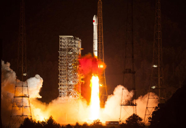
China successfully launched another satellite into space for its indigenous global navigation and positioning network at 11:33 pm on Oct 25, 2012 from the Xichang Satellite Launch Center in the southwestern province of Sichuan. [Photo/Xinhua] |
Beidou, which means compass, now has a constellation of 16 navigation satellites and four experimental satellites.
"Signals from Beidou can be received in countries such as Australia," Ran said.
Its positioning accuracy has also improved, from 25 meters horizontally and 30 meters vertically at the beginning of the trial operation to the current 10 meters both horizontally and vertically, he said.
But in a GPS-dominated market, Beidou needs enterprises to participate in the development of applications for the system. A number of foreign companies have already shown an interest.
Its website (www.beidou.gov.cn) ran both Chinese and English versions of a document that specifies signal-interface relations between the Beidou system and receivers.
Cao Hongjie, vice-president of Beijing UniStrong Science and Technology, which makes navigational products, said the publishing of the document means "domestic companies that have tried to develop Beidou applications for almost a decade will now face competition with foreign companies".
"Many US companies have been waiting for the document," he said.
Related Stories
Beidou's unique services attractive to Chinese companies 2012-12-28 03:06
Document to navigate Beidou to be released 2012-11-10 06:19
China donates Beidou satellite model to UN 2012-06-09 09:16
Launch will boost Beidou 2012-05-17 15:06
Beidou navigates path to larger market share 2012-06-04 11:19
China to launch 3 more satellites for Beidou system 2012-05-16 16:47
Today's Top News
President Xi confident in recovery from quake
H7N9 update: 104 cases, 21 deaths
Telecom workers restore links
Coal mine blast kills 18 in Jilin
Intl scholarship puts China on the map
More bird flu patients discharged
Gold loses sheen, but still a safe bet
US 'turns blind eye to human rights'


Hot Topics
Lunar probe , China growth forecasts, Emission rules get tougher, China seen through 'colored lens', International board,
Editor's Picks
|

|

|

|

|

|