Road trips reveal Xinjiang splendor


Detailed routes give access to the region's diverse cultures and scenic attractions. Cui Jia and Mao Weihua report from Urumqi.
The diverse cultures and breathtaking views found in the vast Xinjiang Uygur autonomous region, which covers a sixth of China's territory, make it perfect for road trips.
Locals often tell people proudly that, apart from the sea, everything on their travel bucket list can be found in the region: golden deserts; great, red-tinged canyons; turquoise high-plateau lakes; and snowcapped mountains. Xinjiang has been described as China's best-kept secret by CNN Travel.
The region's roads have improved considerably in recent years, luring people back for more road trips.
"Many of my clients have told me that driving around Xinjiang is an addiction," said Zheng Jinbin, who runs a recreational vehicle rental company in the regional capital, Urumqi. "So many of them are frequent customers from other parts of China. They particularly enjoy the transitions in scenery, which can sometimes be so different even when they are driving along one road."
The Tianshan Mountains divide the region into two parts - north and south - with different climates and cultures.
Xinjiang is home to people from 14 ethnic groups, and their cultures have been well preserved, while at the same time having greatly influenced their neighbors. In the region, people driving out of a Mongolian autonomous prefecture can find themselves entering a Kazak autonomous prefecture.
Head south to experience Uygur culture and find traces of the ancient Silk Road. Many roads in southern Xinjiang were built along the ancient trade routes connecting China and Central Asia.
You can feel and taste the Silk Road in Xinjiang today. Kuqa county in Aksu has long been famous for its big naan bread, a legacy of the Silk Road. Travelers passing through Kuqa, a kingdom during the Han Dynasty (206 BC-AD 220), needed to stock up on food there, since the next place they could replenish their supplies was far away. Instead of carrying many regular-sized naan, they found it more convenient to carry the bigger version.
Kuqa is just one of the counties in southern Xinjiang whose name resonates with Silk Road history. Driving through them takes travelers on a journey back in time as they pass the names of ancient kingdoms dotted along the edges of the Taklimakan Desert, the world's second-largest shifting sand desert and the largest desert in China.
In ancient times, the Taklimakan, which means "the place of no return" in the Uygur language, was a place travelers were likely to avoid. But modern-day travelers can drive along roads built in the desert for a unique experience.
The first road across the Taklimakan was opened to traffic in 1995. At 522 kilometers, it is still the world's longest desert highway. The second one, stretching 424 km, was completed in 2007, and a third, covering about 330 km, is expected to open in 2021.
"Driving on the road in the Taklimakan is like driving on another planet," said Wang Yong, 63, who has been driving around Xinjiang in a recreational vehicle with his wife. "You are on your own most of the time, with the company of sand dunes that are like ocean waves. Human beings just seem so insignificant."
As of Monday, the couple had spent 40 days in Xinjiang since leaving their home in Yulin, Shaanxi province.
Head north to roam the grassland with Kazak nomads on horseback. And don't be surprised to see a special lane on the highways dedicated to sheep and herdsmen during seasonal migrations. In fact, the drivers are the trespassers because the highways were built on the routes used by locals for thousands of years to move livestock in search of pastures among the mountains.
Unlike other places in China, Xinjiang's vast grassland stretches through mountain valleys, meaning travelers can enjoy views of green pastures against a backdrop of snowcapped mountains.
There are shortcuts in Xinjiang, cutting through the Tianshan Mountains, that allow people to travel between the north and the south of the region. The most famous is the G217, a highway built for military purposes in the 1970s. The 562.7-km road, which is closed in winter, connects Dushanzi, in the city of Karamay in northern Xinjiang, with Kuqa in the south.
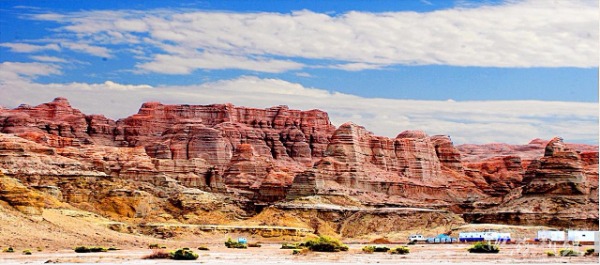
Many have called it the most beautiful road in China, because it takes travelers through the snowcapped Tianshan Mountains, verdant valley grasslands and the Kuqa Grand Canyon.
"As soon as you climb over to the southern side of the Tianshan Mountains, the view changes suddenly," Wang said. "The snow on the mountain vanishes and is replaced by green grassland. You know you've arrived at Kuqa when you are weaving through incredible landforms weathered from red sandstone by wind and rain over centuries. It is just magical."
Long road trips between the scenic spots in the vast region may have put many people off in the past, but more people are now discovering that the road trips might actually be the best part of the journey.
The regional tourism research institute recently released 10 detailed routes in Xinjiang for people to follow while driving around the region at their own pace. Each route takes six to nine days to complete.