China stands firm on Qomolangma altitude


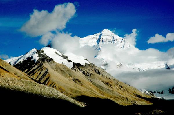
China's top surveying authority denied on Saturday that the country has changed its stand on the official height of Qomolangma, also known as Mount Everest.
The National Administration of Surveying, Mapping and Geoinformation said China maintains the world's highest mountain measures 8,844.43 meters.
The statement came in response to a New York Times report on Feb 3 that quoted Ang Tshering Sherpa, former head of the Nepal Mountaineering Association, as saying China had backed down on its height claim and decided to recognize the Nepali measurement of 8,848 meters.
China's measurement of 8,844.43 meters was made public in 2005 with authorization from the State Council and was determined through processes inscribed in the country's Surveying and Mapping Law, the administration said on Saturday.
"It has been used until now as a nationally unified standard for the height," it added.
China measured the height of the peak for the first time in 1975, stating it was 8,848.13 meters. In 2005, Chinese surveyors assessed the summit again, measuring the height both from the peak's rock base (8,844.43 meters) and from the top of the snow (3.5 meters).
To explain the discrepancy of 3.7 meters between the 1975 and 2005 figures, the administration cited three reasons.
First, surveyors had increased the accuracy of the measurements with the use of more advanced surveillance techniques in 2005.
Second, they accurately measured the height of ice cover for the first time. Since the depth of ice cover changes from time to time, they excluded it from the height of the peak and measured only the height of the rock.
Third, movement of the Earth's crust between 1975 and 2005 had caused the change in the height, the authority said.
China has used the 2005 height as the official standard since it was made public in October that year.
"The accurate measurement and publication of the height of Qomolangma in 2005 is strictly scientific and statutory," the administration said. "As a national official standard, it has also been an important data item widely used in the research of surveying, mapping, geosciences, environment and climate change."
The authority added that it is continuously monitoring Qomolangma.


- Eight dead after minibus collision
- Chinese PLA navy to celebrate 75th founding anniversary with series of events
- Student detained on suspicion of the death of his roommate
- Smart teaching system launched for international Chinese learning
- Shanghai prepares to open parks 24 hours a day
- Action taken over Chongqing Gas Group overcharging